Vazhachal Forest is a lesser touched natural beauty. It fulfills your desire to be far from people, contemplate and enjoy the nature from hills and valleys, waterfalls and thick forest. Vazhachal Forest Division comprises of Athirappilly, Charpa, Vazhachal, Kollathirumedu and Sholayar Ranges.
The Athirappilly-Thumpoormuzhi-Vazhachal DMC has organised a 'Mazha Yatra' (rain trip) for nature lovers. This one day trip starts at 7.45 AM from Chalakkudy PWD Rest House and ends at 7 PM.
A safari through the evergreen forest of Vazhachal forest ranges of Western Ghats - in the Indian state of Kerala, offers you an overwhelming experience. A weekend trip especially in monsoon, bounded with biological garden,with hills and valleys,sprawling grass lands,cascading water falls and spice plantations makes for a great treat to the eyes. So here are 10 major reasons for you to explore the Vazhachal in monsoon.
THUMBOORMUZHY DAM & RIVER VIEW GARDEN
First spot on the way was Thumboormuzhy Dam & River view garden. Upon reaching, we had breakfast from Jawan food corner run by ex-servicemen cooperative colony. They served Iddly, tea and Puttu made out of rice powder and Jackfruit nut powder.
Then a walk through the hanging bridge. Hanging bridge is one of the main attractions in Thumboormuzhy. It is built across the Chalakudy river and it offers a panoramic view of Thumboormuzhy ecotourist spot.
 |
| Hanging bridge |
There is a construction of a weir at Thumboormuzhi across the Chalakudy river and diverting the water for irrigation.

Butterfly garden and children's park are the main attractions here. You will get distant view of the hanging bridge from the view point.
 |
| Butterfly garden and children's park |
ATHIRAPILLY FALLS
Our next place in the chart was the majestic Athirappilly Falls also nicknamed as the Niagara Falls of India . Situated on the Chalakudy river, this 80 ft waterfall gives you a view of the gushing waterfall, photography & selfie spots.
One has to descend a few steps to reach to the bottom of the falls. This largest waterfall in Kerala is set at the entrance of the Sholayar ranges and originates from Anamudi mountains of the Western Ghats. You can reach the top of the falls through well laid steps and return through the main entrance.
 |
| Athirappilly Falls - view from top |
CHARPA FALLS
Next spot was Charpa Falls which is situated close to the Athirappilly Falls. The waterfall is a part of Chalakkudy River and it plunges on to the road during monsoons.
 |
| Charpa Falls |
VAZHACHAL FALLS
Next spot in our chart was Vazhachal Falls which is a rushing watercourse in the Chalakkudy River and is located 5km from Athirappilly Falls.
 |
| Vazhachal Falls |
TRIBAL VILLAGE
Guests can walk around 1 kms through the banks of the River. A shop of rare tribal products is working there. They make their own honey and some of them also make handicrafts.

Soon we left Vazhachal. Just about a kilometer from the Vazhachal check post, you will come across the Vazhachal bridge which takes you to the other side of the river. From here onwards you can expect animal encounters. Immersed in the beauty of the nature, I looked out of the window, expectiong some special sights. Birds chirped endlessly as we rode on the curves.
PERINGAL KUTHU DAM
Next spot was Peringal Kuthu Inspection Bungalow where our lunch was arranged. One can enjoy a nice view of the Dam and the adjoining areas from here.
 |
| Peringal Kuthu Dam |
After having a delicious lunch and rest for some time, we continued our journey. The 40 kms Jungle safari passes through lakes, valleys and thick forest. The cool climate and the majestic view of the jungle makes it an enormous attraction. The road stretched ahead with dozens of curves.
MALAMUZHAKKI VEZHAMBAL
We were lucky to see the 'Malamuzhakki Vezhambal' (The Great Pied Hornbill) which is the bird of Kerala state. The 'Malamuzhakki Vezhambal' is a rare sight in the forests of Kerala.
We were lucky to see the 'Malamuzhakki Vezhambal' (The Great Pied Hornbill) which is the bird of Kerala state. The 'Malamuzhakki Vezhambal' is a rare sight in the forests of Kerala.
 |
| Malamuzhakky vezhambal |
On the left side, you can see the Peringal Kuthu Reservoir.

ANAKKAYAM ( ELEPHANT'S LAKE )
Soon we crossed a narrow bridge, named "Aanakkayam Bridge'. You can watch elephants in this spot, if you are lucky. It is a beautiful scenery in the middle of jungle.

On the way is the Sholayar Power House. The water flowing through these pipes turn the turbines, thus generating power.
LOWER SHOLAYAR DAM
Our last spot in the chart was Lower Sholayar dam.The reservoir is situated in Kerala. Photography is not allowed in the Dam and its surroundings. Nothing much to see in this place except the Dam and reservoir.
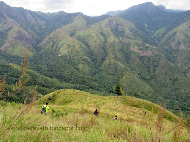
MONSOON TREK
The final activity in this trip was a half an hour trek. As we were on high altitude, the clouds were on the road and this is an experience which I love - passing through the clouds.

Soon we started our return journey. Rain accompanied us throughout the journey. We stopped at Vazhachal for our evening tea. They served " kappa" and hot special herbal coffee which made us feel refreshed especially in the raining day. We were gifted an umbrella and a bag with a kit.
A day well spent!