Comments

3-comments

Korigad Fort Trek

Korigad Fort

Korigad  Fort,  at a height of 929m above sea level, is situated about 20km away from Lonavala on the way to Aamby valley in the Indian state of Maharashtra. We started by a reserved bus from Mumbai at around  6 am and reached Peth Shahpur, the base village by 9 am. Peth Shahapur village is situated at the foothills of the fort. Locals from Korigad village have built up small eating places for the travelers and you can also give them food order before going for trek.

view of the fort from the base

We started walk from Peth Shahpur village and after walking for 25 minutes through forest, we reached in the middle of a well laid steps of Korigad. From this point, stone steps are laid till the top. Since we are trekking in monsoon, water flows over steps and walk itself was amazing. Enroute, there is a Buddhist Cave on the right side, a Buddhist Cave temple and beautiful view of Amby Valley to your left.


Climb to the top of the fort should take around 20 minutes. Climbing on stone steps was quite an easy task. Soon we reached Maha Darwaja. Rain and clouds welcomed us when we reached the fort.


Fort has six canons situated at different places, one is named as "Lakshmi Toaf".


There were 2 lakes on the top and a small gateway through the two lakes is different thing on its own.  A temple to its patron goddess Koraidevi also exists there.


From the top of the fort , you will get the beautiful view of surrounding of the Amby Valley city, Dam and Plane Runway.

Amby Valley city


Plane Runway

The top is a big plateau with a wall running around its side. A huge waterfall is originated from this plateau.  One could walk on the walls of the fort for the entire summit of around 2 hours.


Most of the constructions at the fort are ruined and the fortification is still intact.


After exploring the fort,  we started our return journey. After a 45 minutes walk, we reached  back to the Shahpur village, then proceeded to Mumbai.

A walk down the Cherai Beach : Kerala


As usual we were getting bored on Sunday and wanted to go for an outing nearby.  So we  planned to go for a half day trip to Cherai beach which is just 20 kms from Kochi, Kerala State. 

The beach comes after a charming lake and also one road goes across the lake which is really amazing.

 We can see many Chinese fishing nets on both sides of the road.

It was a cloudy day in the month of July so we were expecting a rain.  As soon as we reached Cherai beach , it started raining and we witnessed the stunning atmosphere around the beach.


It is one of the most  beautiful beaches in Kerala . One of the best experience was sitting on the wet land and watching the waves come and go.

A breathtaking sunset to behold, nothing could have seemed as magnificent.


As the evening descended upon us, we decided to leave the beach and back to home.

There are few restaurants just opposite the beach road serving fresh sea food other than Indian, European, French, Chinese, Continental food.. They do have accommodation facilities too.

We had a beautiful time out there and were happy to find such an amazing place near our home.

The Untouched beauty of Kerala : Athirappilly Waterfalls


Athirappilly Waterfall, Kerala,India

It was a cloudy day in the month of July and this is the perfect time to visit Athirappilly Falls also nicknamed as the Niagara Falls of India . Since it was monsoon the maximum flow occurs during this season.

The Waterfall is located 30 km from Chalakudy town . The one hour drive through the forest from Chalakudy itself was enjoyable. The falls can be viewed from the top where one can see the Chalakudy river flowing down to the falls. 

Athirappilly is one of the most loved and favourite shooting spots of director Mani Ratnam and it can be spotted in his movies like Dil se, Raavan, Guru to name a few. The shooting of  many Malayalam and Bollywood movies have been done here.

This 80 feet high water Fall and the nearby Vazhachal Falls is close to dense green forests and is a part of the Chalakudy river. This largest waterfall in Kerala is set at the entrance of the Sholayar ranges and  originates from Anamudi mountains of the Western Ghats.    

When we reached Athirappilly Falls , it started raining and we could see the source of the waterfall, before flowing down to the falls. We witnessed a stunning atmosphere around the falls. 


To enjoy the waterfall at its very best, we walked across the forests through slippery steps to reach the foot of the falls. Pathways are constructed for easy movement. It takes around 20 minutes to reach the bottom. It is pleasant to stand down the falls by watching the performance of the nature as the water falls and heavy water sprays . The area was covered in mist and it was hard to take any photographs, as the tiny droplets carried by the wind just settled on the lens of my camera. One should take care not to cross the border lines marked by the security staff, which is the safety measure taken by the authorities to prevent accidents.

View from the bottom

After spending  around one hour, we headed to  Charpa and Vazhachal falls. Charpa Falls is close to Athirappilly Falls and it seems to be almost plunges on to the road.

Charpa Falls

Vazhachal falls is located 5km from Athirappilly Falls. There is a small garden and Children's Park near to Vazhachal Falls.  From this garden we can actually view the waterfall. All these are monitored and administered by Vazhachal  Forest Department.

Entrance of  Vazhachal Falls

Plantation Valley between Athirappilly and Chalakkudy looks amazing.

Plantation Valley

On our way back to Chalakudy , we visited Thumboormuzhy Dam and River view Garden.

Thumboormuzhy River view Garden

Nowadays this Thumboormuzhy park is one of the important eco-tourism attractions in Chalakudy- Athirapally Ecotourism. Located 12km way from Athirappilly, Thumboormuzhi Dam is an irrigation dam built on the Chalakkudy river.

If you are a fan of nature and love to travel, then Athirappilly Falls must be in your list.  

Unexplored Anangan Mala Hill Tourism,Kerala


It was quite an unexpected visit to Anangan Mala Hills. I was travelling to Cherpullasserry and just before reaching Ananganadi junction, I saw a huge hill - the famous Anangan Hills. Then I came to know that there is an Eco tourism spot on the valley of Anangan Hills. 

About Anangan Hills:
Ananganmala is situated at Ananganadi in Palakkad district of Kerala state, India. These hills stretch 10 km , covering 3 Panchayaths and Ottapalam municipality, Peak height is 1200 metre from ground level. It comes under the Ottapalam Forest Range of Palakkad Forest Division, Kerala State.

History:
Folklore say that a piece of the mountain Lord Hanuman carried from Himalayas to Sri Lanka fell, as he flew over Ottapalam, and this is the Hill - Anangan Mala (meaning mountain that cannot be moved in local language).

What you can do?

1. It is an ideal place for adventurous rock climbing
2. It is ideal for an outing with entire family
3. It is a perfect place for shooting film, serials and wedding albums. Malayalam Films like Aaraam Thampuran and Arayannangalude Veedu were shooted here.

River Rafting in Kundalika River, Kolad, Maharashtra


Kundalika is a beautiful river originating in the Western Ghats of Maharashtra  and ending into the Arabian Sea near the creek at Roha.  The river flows through thick forests and it is the only river in Maharashtra on which white water rafting is possible.  The river Kundalika is fed by the excess water from Tata Power's Mulshi Dam Project on to a series of hydroelectric projects and dams. Rafting is done in the rapids which are generated by the water released from the dam .  The river Kundalika  offers you a stretch of 14km of exciting rapids with Grade 3.

Started off at around 6 am from Vashi to our destination.  Enroute there was a small halt for breakfast.  We were a bit late when we reached the rafting point.  Everyone was already excited. They provided life jackets and helmets. We were given a 5-minute crash course before getting on the raft, and off we go! 

The rain started drizzling and it added more excitement to our adventurous journey. We started rafting with the guide. We watched other rafts drift ahead of us and surging into the mighty waters of Kundalika.

Our guide had a good sense of humour. He was continuously giving instructions and information about the rapids and everyone listened to him with curiosity.  He explained about ten rapids with funny names like Johnny Walker and Mini Mouse and these stories were enough to increase our curiosity.


And after a thrilling 45 minute ride, we reached the still waters of Kundalika .  Our guide asked us to jump into the water and swim . He said no swimming skill is required as we already had a life jacket.  And I waited some more time in the boat watching what others are doing. I finally began enjoying the water and learnt to relax. The best of  rafting was that of lying on the water and watching the sky above. We enjoyed for  about 2 hours on water by swimming and playing .


The rafting ended when the guide asked us to  lift the raft and carry it to the top.

Then we started off our back journey with a lovely lunch.  An amazing and lovely adventurous day with new friends and sweet memories.

A day well spent!

Palasdari fort Trek

Palasdari fort
 
Palasdari fort also known as Songiri fort is situated near Palasdari Railway station, Karjat, in the Indian state of Maharashtra.

To reach Palasdari station, One needs to get down at Karjat Station. We had our breakfast at  Karjat station.  The coordinators already brought Idli, Vada and tea. Then we catched  "Karjat-Khopoli" local train which stops at Palasdari Railway station. Since Palasdari is not developed commercially, there are no restaurants or hotels. But the villagers are always ready to extend their hospitality if demanded.  The village name is derived from "Palas" tree and "Dhari" means Mountain Pass.

Further walk along the railway track will take you to a tunnel. The trek starts from Palasdari tunnel. You will notice a hillock on the left side  and proceed upwards towards dome-shaped hillock. The dome is clearly visible only after crossing two plateau's.

Palasdari tunnel

The trek continues through dense forest and finding the routs is challenging and tricky.  The thrilling route makes Palasdari trek worth doing.  Further the trial goes through grass which was double higher than us.


Rain god had already blessed and everything around turned  green. We passed through beautiful landscapes, listening to birds chirping. We had a halt in between to enjoy the cool breeze around.


As we were doing this trek in the Monsoon, many people were slipping while walking through the final portion of the trek.


Reaching to the furthest end requires good amount of skill as there is a rocky patch to overcome. It took around 3 hours to reach the top.


There are not much of fort structures at the top except few ramparts, fortifications and two water tanks. We rested here around 30 minutes looking at the beauty of surrounding area . We sat at the edge of the hill just sitting and feeling the wind and the sun.


View of surrounding area from top of the fort is spectacular. We got a beautiful view of  Rajmachi, Dhak, Bhivgad and Prabalgad  from top. This fort also offers good view of  Palasdhari Lake, Irshal fort, Morbe dam and Ulhas river.


The Karjat-Khopoli Railway track were well in line of sight.

View of Karjat-Khopoli Railway line from top


After exploring the top and surroundings, we started our descending. Descending was quite risky.


Soon, we completed our descending of  Palasdari fort and reached near tunnel.   Overall it was a memorable experience.


Kalsubai - Highest peak in the Sahyadris in Maharashtra


A good friend, a bike in good condition, good road with fantastic views on each side and excitement of first trek.  Enough reasons for me to select Kalsubai Trek - the  highest peak in Maharashtra,  that lies within the Kalsubai Harishchandragad Wildlife Sanctuary. 
  
ENROUTE TO BARI VILLAGE

Myself and my friend Vishu started from Navi Mumbai in his bike at around 2 AM and the bike ride itself was thrilling.

And that’s how we went for experiencing the new world.


Our route was  Navi Mumbai - Thane - Mumbai Nasik Highway -  Igatpuri -  Bari.

We took a  right turn from Igatpuri on the Mumbai Nasik route to reach Bari . This route is a good choice for bike riders. Another option to reach Bari from Mumbai is through local train and get down at Kasara station. From Kasara one can get buses and share taxis to get down at Bari.

We had our breakfast from a hotel on the way. We reached Bari Village at around 8 AM after few halts.  Bari is a small village surrounded by vast mountain ranges and lush green paddy fields. Parked the bike in one of the villager's house. We ordered for food also from there, so that they can keep it ready when we come down. We had to cross the village to start our trekking.

About Kalsubai:
Height: ~ 5400 feet 
Grade: Medium
Time: ~ Maximum 3 hrs. from Bari.
Location: Igatpuri

And step towards my first trek.


Initially, we crossed the muddy trails with ease, but these soon graduated to steep paths. After a half-an-hour we reached a plateau and that was also our first resting point. From here one can see the ladders that are built on the rock patches.

climb to the top


There are many small stalls for food like lemon water, kakdi (cucumber) etc. and this was enjoyable during halt.  There is a small well before reaching Kalsubai peak. We filled our bottle with that water and washed our face and hands.


After two hours of trekking and climbing two ladders, we reached the plateau from there it took another 40 minutes trek to reach the final ladder.
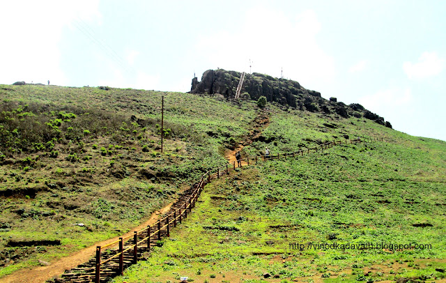
Few minutes more to reach the top

After scaling the final Ladder we reached the summit -  top of Maharashtra. The summit is an open area with a small red shrine dedicated to Kalsubai, a local goddess. 

As per legends, this temple of local deity Kalsubai, is named after a lady who vanished at this mountain while aspiring to get away from anguish of her employer. 

Kalasubai top temple

And the view from the top was mesmerizing. Meditating at the top of Maharashtra is a lifetime experience


The blow of gusty wind made me feel like a leaf and I just loved that.


Kalsubai offers a panoramic view of other mountain range forts.

Towards west Alang, Madangad, Kulang can be seen and to the east Aundha, Vishramgad, Bitangad , to the east Aundha, Vishramgad, Bitangad can be seen. 

Towards north  Ramsej, Harihargad, Brahmagiri, Anjaneri, Ghargad, Bahula, Tringalwadi, Kavnai , to the south Pabhargad, Ghanchakkar, Harishchandragad can be seen .

Another view from top is famous Bhandardara Lake.

There was a chain  which is metallic, and is something like 30 meter long. You throw it downward, with one end tied on to the hill top. Then you have to pull it back, in one stretch.

After spending around one hour at the top, we started descending.


It was a thrilling experience to stepping on to steel strips by holding on to the railing/side bars.

final ladder


And mile to go

When we reached village, a delicious lunch of bhakri, batata ki sabzi , rice and daal was waiting for us. Even though this was my first trek, I never felt it as difficult and will always cherish the memories. And we drove back to home with memories of conquering Top of Maharashtra!