Comments

3-comments
Showing posts with label Trekking in Tamilnadu. Show all posts

Mountain Getaway : Meghamalai


Meghamalai  is located in the Western Ghats in Theni zone, the Indian state of Tamil Nadu and is situated at an altitude of 1,500 m above sea level.

At 5.30 am,  our party of 26 boarded the van from Kochi. When each one of us boarded from different locations, we exchanged quiet good-mornings and set off through the darkness. Our route was,  Kochi - Idukki - Kumily - Cumbum - Chinnamanur - Megamalai

After breakfast at Neriamangalam and frequent halts, we crossed Kumily check post by noon. Unplanned stops are always a pleasure especially when you are travelling through high ranges. From Cumbum onwards, we passed through paddy fields, Coconut and grape plantations. Meghamalai mountain range can be approached in two ways - via Chinnamanur and from Andipatti via Kandamanayakkanur.  Our route was via Chinnamannur which is more scenic. We took a right turn from Chinnamannur town and along the outskirts of Chinnamannur town, the road was surrounded by towering hillocks which is the reserve forest area.

Meghamalai is not a famous travel spot among the tourists. After crossing Chinnamannur check post, we were greeted by ghat road. We were negotiating with dozens of sharp hairpin bends.
 
You can see traces of Cinnamannur village on the other side. There were view points at some places and the views kept getting better as we went higher.

Just before reaching Meghamalai, the tea estates greeted us with a greenish grin. The ride ended near a temple surrounded by tea estates. Most of the 6000 acres of tea plantation in Meghamalai is owned by the private tea planters. It’s so hard to spot any restaurants or hotels in this place.


And we started walking towards our base camp. As I made  my way through the tea-carpeted hills of Meghamalai,  I found workers going back to their home after a busy day.


Since Meghamalai is part of Western Ghats, this place resembles Ooty or Munnar because of its cool and misty mountain ranges.  First few minutes of our walk was through tea estates. The neat tea-lined valleys and a walk through the plantations that shaped Meghamalai make for a tasteful break.


Then we made our way through the forest with steep hiking. Every trial offers a fresh adventure whether it is through forest or plantations.

After half an hour walk through tea estates and forest,  we reached the base camp at around 4 pm. Our base camp was set up on a ridge looking out at the valley but clouds had gathered,  obscuring views of the valley. Simple vegetarian lunch was waiting for us.

Our actual plan was a two hour nature walk but we skipped our plan as we were already late. After resting for some time, we were busy with tent setting  and food preparation. Chicken was highly featured in the dinner. The whether was cool and there was heavy storm and mist in the area.

DAY 2

When I stepped out of my tent at dawn,  I saw the surrounding stripped of cloud cover followed by heavy wind.

After a quick breakfast of Upma, we set off.  Our destination was 'Varayadu Motta' which is famous for the presence of Nilgiri Tahr.  'Motta' means barren hills. There are five 'Mottas' in this region. There are many routes to reach the 'Varayadu Motta'. But we took the longest route through a combination of plantations, thick forest and open meadows.

After crossing the forest area, we entered the beautiful tea estate. You will be mesmerized with views of the deep valley and the forest-covered hillsides.


When you go higher, you will get a good view of the surrounding valleys and views of small towns and villages surrounded by mountains.  It took us a little around three hours to reach the first hill top, through mostly flat terrain, making plenty of stops to admire the flora and fauna along the way.


There were plenty of ascents and descents that varied through tea estates, coffee plantations and thick forests.

Since the area is a reserved forest area, which always means that there is the possibility of sighting animals like elephants, Indian gaur, deer etc. We were in a constant lookout for animals, but had no luck. We found elephant dung on the way. Beware of leeches as  we ended up with few leech bites inside the forest.

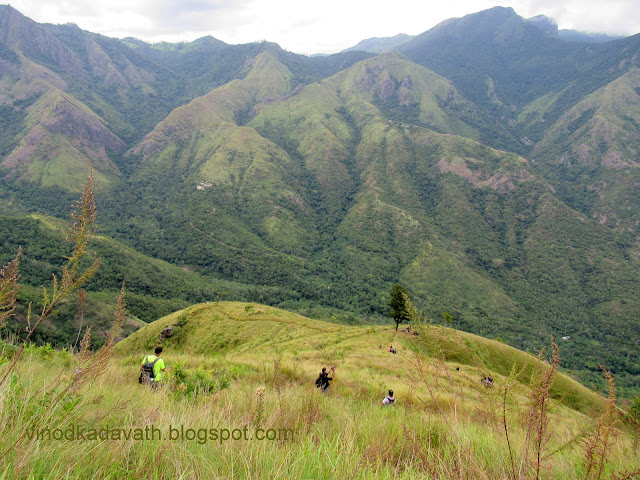
And we climbed  the hill.  It was such a peaceful place with virgin mountains.  Then the trek towards the peak where clouds covered the mountains begins. And we walked down through narrow edges towards the hill. Heavy wind was blowing and we tried to balance our self while walking through the edges.


We were in the middle of no where.  From this point, you will get a panoramic view of the mountains around for its sloping terrain. The plan was to walk till the end of the hill. Wind was blowing heavily and all of us were  trying to balance and some of us even sat down. My legs were shivering. We sat at the edge of the valley. Without taking further risk, we decided to return.


Returned to the base camp at around 2 pm. After lunch and rest for some time, we started our return journey.  Enroute, just  before reaching the check post, we had a pit stop for tea and snacks. After descending the ghat road and another ascending ghat road till Kumily, we stopped at Kumily town for dinner. From Kumily to Kochi, we retraced the route that  me and my wife had visited two weeks back on our vacation to Thekkady.

Prior permission is an absolute must to visit Meghamalai. Since this is a reserved forest area,  you must reach the check-post at least before 6 PM.

Kolukkumala-Kurangani-Top Station trek


The Munnar mountain ranges is one of the most sought after trekking destinaton in Kerala, having borders with Tamilnadu. Kolukkumalai-Kurangani-Tops Station trek is a treking journey of two days and is ideal for both adventure and nature lovers who wish to enjoy the beauty of landscapes and valleys in the backdrop of stunning peaks. The places are actually in Tamailnadu . The trekking route mainly comprises of mountain walking and is considered as moderate difficulty level trekking.

DAY 1

ENROUTE TO MUNNAR

I started my journey from Kochi at around 5.30 AM in my car. The road trip from Kochi to Munnar is merely three and half-hour journey. Enroute is the famous Cheeyappara and Valara waterfalls. The zigzag road will keep you company for the most of your journey. As you are approaching Munnar, all your senses will be in for a treat courtesy of the expansive tea plantations.  I reached Munnar at around 9.30AM. Parked my car in the parking area which is managed by Munnar Grama Panchayat and they charged Rs.50 for two days.

ENROUTE TO KOLUKKUMALAI

Started our jeep safari to Kolukkumalai at around 10.30 am. The jeep passed through a narrow road amidst tea estates. Enroute we had a pit stop at view point.


We reached Suryanelli at around 11.30 AM. Then off road journey from Suryanelli to Kolukkumalai through private property of Harissons Malayalam Ltd. We had a short stop at Kolukkumala view point.  Kolukkumalai Hills, which is the highest place for tea plantation in the world lies at an altitude close to 8,000 feet. You will get great views of Bodinayakanur town and top station valley from this view point. The tea factory is just 1.5 kms from view point.

We reached Kolukkumalai tea factory at around 12.30 PM. Upon reaching, we had a cup of tea from the factory outlet and visited the tea factory. The tea factory tour will enable you to see how the leaves are finally makes way to the cups. You will be shown how tea is withered, rolled, fermented, dried and sorted.

Tea factory and surroundings

The Kolukkumalai tea estate was set up by the British back in the 1930s. Instead of the mechanised crush-tear-curl method, tea leaves are handpicked and then put through controlled drying processes of withering and fermenting. 

KOLUKKUMALAI TO KURANGANI

From  Kolukkumalai walk downhill, alongside the Kulirumalai Gorge to reach Korangani village. Started our descend at around 1.30 pm . Initial trial goes through shola forest. The route was small and full of greenery.

KURANGINI CRATER

Then the trek goes along Korangini crater. The zig zag trial was enjoyable through grass land. Passing through the narrow path of grass land, it’s a wonderful journey enjoying the pictorial beauty of  the valleys.

Grass land trek

The trail is a treat for the eyes as you soak in the views of lush green vistas and the beautiful view of top station valley.  We had our packed lunch under one lonely tree.


Rolling hills and the valley lend a surreal  feel to the breathtaking scenery and we had a frequent pit stop for photography.


The next day the trek continues to Top station which is based at an elevation of 6,000 feet. We could see the top station trail path .  The sight was inspiring.

Top station trek path

Then the trek goes through Kolukkumalai edge overlooking Body hills. You will get a clear view of Theni, Bodynaykur village and Kodaikanal mountain ranges.


You can see  incredible vibrant colors - the deep blue sky and the mountains covered by green mat. As all the goodness sinks in, you are sure to lose yourself.


The rest of the trek was through the small shola forest.

At around 6.30 pm, we reached Kuragani village. It was a 12 km walk to Kuragani village. Kurangani is a small village located in the foothill of Kolukkumalai Mountains. Again we had a 3 kms jeep ride to reach the camp site.

Village and surroundings

CAMP AT KURANGINI

The package of treks from Kolukkumalai to Kurangini and then to Topstation is arranged by Top Station Eco Torusism. The package includes stay at campsite of Kurangini with dinner,  breakfast and packed lunch for the second day. Hall and tents are available in different sizes at the camp site.

DAY 2

It was around 6.30  AM. After a restful night sleep, I was already jumping to start my day. After an energetic black tea, we visited the view point. It is a sight to behold the formations of different shades on the hills during sun rise.


ASCEND

Had our breakfast and started our trek at around  9.30 AM. The initial trial was through mud jeep road path till a small village called Central station.

Soon we reached in Central station which is situated at the bottom of the hills. Took rest for sometime before starting steep hike through grasslands to the Top station.

at Central station

We could also see the trail down the hill from the top of Kolukkumala to Korangini which we took yesterday.

ClLIFF-EDGE WALKS

It was an awesome experience by walking through the edge of the grassland, marveling the beauty of vibrant surroundings and rock structure.


Had our packed lunch near a big rock on the way. The final stretch was a steep climb without any proper trek route. This trial is considered as the most famous and challenging trail in this area.


Finaly we reached top station view point at around 3.30 PM. The 12 km hike from Kurangani village to Top Station through Central village is a journey to be cherished.  From the view point, you will get a breathtaking view of the Top station valley, Kolukkumalai and Meesapulimala Peak.

Top station view point

On the whole it’s a physically demanding and laborious trek , with a different experience of steep climbing, shola forest, grasslands and villages. However, it is an effort worth taken in every sense.