Comments

3-comments

10 Reasons to explore Vazhachal in Monsoon!


Vazhachal Forest is a lesser touched natural beauty. It fulfills your desire to be far from people, contemplate and enjoy the nature from hills and valleys, waterfalls and thick forest. Vazhachal Forest Division comprises of Athirappilly, Charpa, Vazhachal, Kollathirumedu and Sholayar Ranges.

The Athirappilly-Thumpoormuzhi-Vazhachal DMC has organised a 'Mazha Yatra' (rain trip) for nature lovers. This one day trip starts at 7.45 AM from Chalakkudy PWD Rest House and ends at 7 PM.

A safari through the evergreen forest of Vazhachal forest ranges of Western Ghats - in the Indian state of Kerala,  offers you an overwhelming experience. A weekend trip especially in monsoon, bounded with biological garden,with hills and valleys,sprawling grass lands,cascading water falls and spice plantations makes for a great treat to the eyes. So here are 10 major reasons for you to explore the Vazhachal in monsoon.

THUMBOORMUZHY DAM & RIVER VIEW GARDEN

First spot on the way was Thumboormuzhy Dam & River view garden. Upon reaching, we had breakfast from Jawan food corner run by ex-servicemen cooperative colony. They served Iddly, tea and Puttu made out of rice powder and Jackfruit nut powder.

Then a walk through the hanging bridge. Hanging bridge is one of the main attractions in Thumboormuzhy. It is built across the Chalakudy river and it offers a panoramic view of Thumboormuzhy ecotourist spot.

Hanging bridge

There is a  construction of a weir at Thumboormuzhi across the Chalakudy river and diverting the water for irrigation.


Butterfly garden and children's park are the main attractions here. You will get distant view of  the hanging bridge from the view point.

Butterfly garden and children's park

ATHIRAPILLY FALLS

Our next place in the chart was the majestic Athirappilly Falls also nicknamed as the Niagara Falls of India .  Situated on the Chalakudy river, this 80 ft waterfall  gives you a view of the gushing waterfall, photography & selfie spots.

One has to descend a few steps to reach to the bottom of the falls.  This largest waterfall in Kerala is set at the entrance of the Sholayar ranges and  originates from Anamudi mountains of the Western Ghats. You can reach the top of the falls through well laid steps and return through the main entrance.

Athirappilly Falls - view from top

CHARPA FALLS

Next spot was Charpa Falls which is situated close to the Athirappilly Falls. The waterfall is a part of Chalakkudy River and it plunges on to the road during monsoons.

Charpa Falls

VAZHACHAL FALLS

Next spot in our chart was Vazhachal Falls which is a rushing watercourse in the Chalakkudy River and is located 5km from Athirappilly Falls.

Vazhachal Falls

TRIBAL VILLAGE

Guests can walk around 1 kms through the banks of the River. A shop of rare tribal products is working there. They make their own honey and some of them also make handicrafts.


Soon we left Vazhachal. Just about a kilometer from the Vazhachal check post, you will come across the Vazhachal bridge which takes you to the other side of the river. From here onwards you can expect animal encounters. Immersed in the beauty of the nature, I looked out of the window, expectiong some special sights. Birds chirped endlessly as we rode on the curves.

PERINGAL KUTHU DAM

Next spot was Peringal Kuthu Inspection Bungalow where our lunch was arranged. One can enjoy a nice view of the Dam and the adjoining areas from here.

Peringal Kuthu Dam

After having a delicious lunch and rest for some time, we continued our journey.  The 40 kms Jungle safari passes through lakes, valleys and thick forest. The cool climate and the majestic view of the jungle makes it an enormous attraction. The road stretched  ahead with dozens of curves.

MALAMUZHAKKI VEZHAMBAL

We were lucky to see the 'Malamuzhakki Vezhambal'  (The Great Pied Hornbill) which is the bird of Kerala state. The 'Malamuzhakki  Vezhambal' is a rare sight in the forests of Kerala.

Malamuzhakky vezhambal

On the left side, you can see the  Peringal Kuthu Reservoir.


ANAKKAYAM ( ELEPHANT'S LAKE )

Soon we crossed a narrow bridge, named  "Aanakkayam Bridge'. You can watch elephants in this spot, if you are lucky. It is a beautiful scenery in the middle of jungle.

On the way is the Sholayar Power House. The water flowing through these pipes turn the turbines, thus generating power.

LOWER SHOLAYAR DAM

Our last spot in the chart was Lower Sholayar dam.The reservoir is situated in Kerala. Photography is not allowed in the Dam and its surroundings. Nothing much to see in this place except the Dam and reservoir.

MONSOON TREK

The final activity in this trip was a half an hour trek. As we were on high altitude, the clouds were on the road and this is an  experience which I love - passing through the clouds.

Soon we started our return journey. Rain accompanied us throughout the journey. We stopped at Vazhachal for our evening tea. They served " kappa" and hot special herbal coffee which made us feel refreshed especially in the raining day. We were gifted an umbrella and a bag with a kit.

A day well spent!

Kolukkumala-Kurangani-Top Station trek


The Munnar mountain ranges is one of the most sought after trekking destinaton in Kerala, having borders with Tamilnadu. Kolukkumalai-Kurangani-Tops Station trek is a treking journey of two days and is ideal for both adventure and nature lovers who wish to enjoy the beauty of landscapes and valleys in the backdrop of stunning peaks. The places are actually in Tamailnadu . The trekking route mainly comprises of mountain walking and is considered as moderate difficulty level trekking.

DAY 1

ENROUTE TO MUNNAR

I started my journey from Kochi at around 5.30 AM in my car. The road trip from Kochi to Munnar is merely three and half-hour journey. Enroute is the famous Cheeyappara and Valara waterfalls. The zigzag road will keep you company for the most of your journey. As you are approaching Munnar, all your senses will be in for a treat courtesy of the expansive tea plantations.  I reached Munnar at around 9.30AM. Parked my car in the parking area which is managed by Munnar Grama Panchayat and they charged Rs.50 for two days.

ENROUTE TO KOLUKKUMALAI

Started our jeep safari to Kolukkumalai at around 10.30 am. The jeep passed through a narrow road amidst tea estates. Enroute we had a pit stop at view point.


We reached Suryanelli at around 11.30 AM. Then off road journey from Suryanelli to Kolukkumalai through private property of Harissons Malayalam Ltd. We had a short stop at Kolukkumala view point.  Kolukkumalai Hills, which is the highest place for tea plantation in the world lies at an altitude close to 8,000 feet. You will get great views of Bodinayakanur town and top station valley from this view point. The tea factory is just 1.5 kms from view point.

We reached Kolukkumalai tea factory at around 12.30 PM. Upon reaching, we had a cup of tea from the factory outlet and visited the tea factory. The tea factory tour will enable you to see how the leaves are finally makes way to the cups. You will be shown how tea is withered, rolled, fermented, dried and sorted.

Tea factory and surroundings

The Kolukkumalai tea estate was set up by the British back in the 1930s. Instead of the mechanised crush-tear-curl method, tea leaves are handpicked and then put through controlled drying processes of withering and fermenting. 

KOLUKKUMALAI TO KURANGANI

From  Kolukkumalai walk downhill, alongside the Kulirumalai Gorge to reach Korangani village. Started our descend at around 1.30 pm . Initial trial goes through shola forest. The route was small and full of greenery.

KURANGINI CRATER

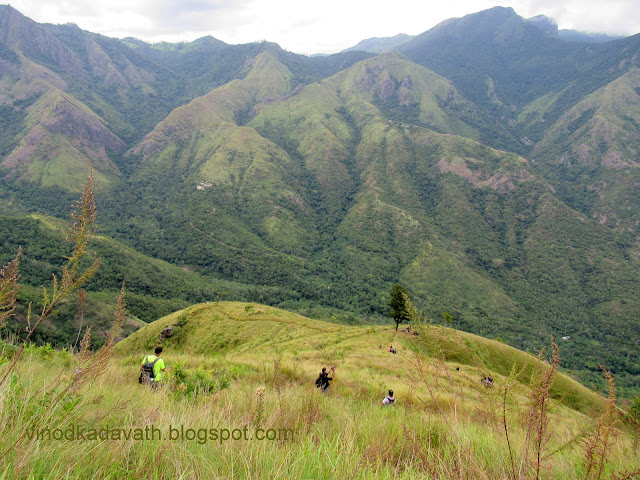
Then the trek goes along Korangini crater. The zig zag trial was enjoyable through grass land. Passing through the narrow path of grass land, it’s a wonderful journey enjoying the pictorial beauty of  the valleys.

Grass land trek

The trail is a treat for the eyes as you soak in the views of lush green vistas and the beautiful view of top station valley.  We had our packed lunch under one lonely tree.


Rolling hills and the valley lend a surreal  feel to the breathtaking scenery and we had a frequent pit stop for photography.


The next day the trek continues to Top station which is based at an elevation of 6,000 feet. We could see the top station trail path .  The sight was inspiring.

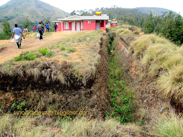
Top station trek path

Then the trek goes through Kolukkumalai edge overlooking Body hills. You will get a clear view of Theni, Bodynaykur village and Kodaikanal mountain ranges.


You can see  incredible vibrant colors - the deep blue sky and the mountains covered by green mat. As all the goodness sinks in, you are sure to lose yourself.


The rest of the trek was through the small shola forest.

At around 6.30 pm, we reached Kuragani village. It was a 12 km walk to Kuragani village. Kurangani is a small village located in the foothill of Kolukkumalai Mountains. Again we had a 3 kms jeep ride to reach the camp site.

Village and surroundings

CAMP AT KURANGINI

The package of treks from Kolukkumalai to Kurangini and then to Topstation is arranged by Top Station Eco Torusism. The package includes stay at campsite of Kurangini with dinner,  breakfast and packed lunch for the second day. Hall and tents are available in different sizes at the camp site.

DAY 2

It was around 6.30  AM. After a restful night sleep, I was already jumping to start my day. After an energetic black tea, we visited the view point. It is a sight to behold the formations of different shades on the hills during sun rise.


ASCEND

Had our breakfast and started our trek at around  9.30 AM. The initial trial was through mud jeep road path till a small village called Central station.

Soon we reached in Central station which is situated at the bottom of the hills. Took rest for sometime before starting steep hike through grasslands to the Top station.

at Central station

We could also see the trail down the hill from the top of Kolukkumala to Korangini which we took yesterday.

ClLIFF-EDGE WALKS

It was an awesome experience by walking through the edge of the grassland, marveling the beauty of vibrant surroundings and rock structure.


Had our packed lunch near a big rock on the way. The final stretch was a steep climb without any proper trek route. This trial is considered as the most famous and challenging trail in this area.


Finaly we reached top station view point at around 3.30 PM. The 12 km hike from Kurangani village to Top Station through Central village is a journey to be cherished.  From the view point, you will get a breathtaking view of the Top station valley, Kolukkumalai and Meesapulimala Peak.

Top station view point

On the whole it’s a physically demanding and laborious trek , with a different experience of steep climbing, shola forest, grasslands and villages. However, it is an effort worth taken in every sense. 

Into the Wilderness of Shendurney Wildlife Sanctuary, Kerala


Beautiful and mysterious, Kerala is one of the most unexplored part of India that many traveler's have  not visited by choice.  With an exceptional array of places to visit - hidden places in Sanctuary's, valleys, and waterfalls, there are enough to surprise any traveller.

Shendurney Wildlife Sanctuary is one of  Kerala's most pristine national treasure.  The breathtakingly beautiful expanse of Shendurney Wildlife Sanctuary unfolds on nature's canvas like a traveler's dream.

DAY 1

ENROUTE TO THENMALA

To experience  Kerala's most pristine national treasure, I started my journey from Thirivananthapuram at around 9.30 AM in my car. I took the Thiruvananthapuram - Chenkotta highway which is a scenic one. Enroute is the famous Kulathupuzha Sastha temple. After 72 kms drive, I reached Thenmala at around 12 PM. Parked my car in front of the dam where all team members were supposed to assemble. Since few of our team members were yet to arrive, we decided to explore the dam and its surroundings.

EXPLORING THENMALA DAM

Thenmala dam is the second largest irrigation project in Kerala and is built across Kallada river. You can visit the dam and its surroundings by taking an entry ticket for Rs.10. Photography is not allowed in the dam premises. You have to walk a lot of steps to reach the top.  This place is blessed with natural beauty. A long walk through the tar road from the other side of the dam takes you to the main road.
Thenmala Dam

Then we moved to Forest Information Centre of  Shendurney Wildlife Sanctuary which is half kms from the Dam junction. By 2.30 PM, our bus was ready. After verification of identity, we boarded the bus which takes you to the boating centre. After a shorter bus ride of 2 kms, we reached the boating centre.

BOATING

At around 3 PM, we started out boating. The main attraction of this package is the boating in Parappar reservoir on the way to the Idimuzhangan camp shed.  Stretching for plenty of kilometers with the blue water beside, the ride will definitely make you awe. The weather is comfortably cool and the water level is around 85 ft.

Enroute, we had a pit stop for packed lunch. We spent some time for photography and enjoyed the beauty of the sprawling expanse of reservoir. You can see the incredible vibrant colors - the deep blue sky, the mountains covered by green mat and the water body surrounded by beautiful landscapes. As all the goodness sinks in, you are sure to lose yourself.


Unpredictable and vast, the forests and the reservoir are home to wild animals, birds and other species.One can often spot them in their natural habitat which is enriched with flora and fauna.

We saw these elephants strolling through the forest.


The boating ended at around 5.30 pm. It was an awesome experience as it allowed us to immerse into the tranquil natural charm of Shendurney Wildlife Sanctuary.

Then a short walk of 2 kms to the base camp - Idimuzhangan camp site.


There is a vast area in front of the camp site. We could see heavy footsteps of a Indian Gaur on the way.


JUNGLE CAMPING

There are various camping packages run by Shendurney Ecotourism. Idimuzhangan is one of the camping site of Shendurney Wildlife Sanctuary beside the Parappar reservoir.  There should be atleast 5 persons to get the permission for camping. As part of the package, they will allot a cook, a guide and a staff to accompany the team of tourists.  As the name suggests, if you make a loud noise in this place, an echo will be formed.

It was around 6 PM when we reached the camp site. The site was protected from wild animals by fenced electric wires and a moat. There were two  bath attached rooms which can accommodate 3-4 persons in each room. One veranda, kitchen and an open area with campfire facility is also part of the site. No phone or Internet connectivity is available in this area.


LEISURE TIME

After having rest for sometime, we moved to the nearby stream for bath. It was a big relief for us after an entire day of travel. It was around 7 PM when we came back to the campsite. Upon reaching, hot black tea was served. Meanwhile, the campfire was also ready. We spent some time singing songs.

It was time for dinner. Our host had prepared tasty meals for us.


DAY 2

It was around 6 AM. After a restful night sleep, I was already jumping to start my day. After an energetic black tea, we moved to bathe in the stream - Natural Spa in streams.

And we walked up the falls, cooling off in the pools forming below them, and a shower under natural water.


ROAMING AROUND

It doesn't make sense if you spend your misty morning in the camp shed. Since we are staying in the buffer zone of the sanctuary, we decided to have a morning walk in the lap of wilderness expecting elephants roam in the grasslands . The area is packed with astonishing sites and remarkable destinations.


Spotted the  skeletal remains of a Indian Gaur which was  attacked by a tiger.


We were lucky to have a distant view of a Indian Gaur strolling through the forest.


Again we returned to the base camp at around 9.30 am.


THE TREK

There are various trials, hikers can choose based on their skills. We decided to take the moderate trial to Nirapara. The Nirapara Trial takes the hiker through the magnificent forest.

Then we started the forest trek at around 9.30 AM.  It was an awesome experience by walking through the forest, marveling the peaceful surroundings and sensing the jungle music.


Spotted moottil pazham( fruit which was used by tribes in ancient days).


The forest area is rich in flora and fauna and various medicinal plants. Spotted an artificial pond for elephants.

Soon we reached Nirapara. The Nirapara spot offers a spectacular view of rock formation and distant view of reservoir with forest as a background, to hikers.


After a little rest and photography, we resumed our trek back to the camp site. Enroute we spotted a big tree. We found many of these on our way in different size.

Reached back to campsite at around 2.30 pm. The trek has come to symbolize Kerala's stunning scenic wealth. It was around 10 kms hiking route that took around 5 hours and the path takes you to wonderful landscapes.

After having lunch and rest for some time, we started our return journey to Thenmala.

Whether you are a adventurer, peace searcher, nature admirer or lover of photography, you can enjoy everything here. It was a memorable two days in the forest.

Camping And Trekking At Meesapulimala


"Munnar never ends at Munnar"... True indeed !!! ....You have to go further to find the real treasures of the Western Ghats".


Meesapulimala is one such hidden treasure in Munnar Western Ghats ranges, in the Indian state of Kerala.  It is the second highest peak in South India and is one of  UNESCO 's world heritage sites.

To enjoy the hidden treasure of Munnar - Meesapulimala, we started our journey from Kochi at around 9 am in a private car. After having breakfast from the roadside eateries, we again resumed our journey. Finally we reached Munnar at around 1 pm after few frequent halts. It was already lunch time.  Our  lunch was in a restaurant near Munnar town, a typical Non Veg Thali which offers locally sourced cuisine  in a very relaxed atmosphere. After having lunch, we moved to KFDC (Kerala Forest Development Corporation ) office at Rose Gardens which is just 3 kms from Munnar bus depot.

Rose Garden, Munnar

Meeshapulimala tour is arranged by Kerala Forest Development Corporation. There are three types of accommodation available for overnight packages. Base camp accommodation ( Tent) is more economical. You can also select Sky cottage or Rhodo valley accommodation.

ENROUTE TO BASE CAMP

At around 2 PM, our jeep was ready. Base camp is 25 kms away from Rose Garden. The jeep passed through a narrow road amidst tea estates for the first few kilometers, after which the journey was off-road...an altogether different experience !! . However we enjoyed the jeep ride through the tea plantations of Kannnan Devan hills and it took around 45 minutes to reach there.

At around 3 pm, we reached the base camp. The campsite,  the highest ( 2050 feet ) and coolest, is situated in a beautiful landscape. The temperature was 14 degree celsius. This is the place where electricity is generated using a micro turbine. Upon reaching, you need to make an entry by writing your address and contact details . Soon we were allotted tents.

Base Campsite


LEISURE TIME

At around 4.30 p.m.,  tea and biscuits were ready. We strolled  leisurely towards sky cottage from where you  get a beautiful view of the waterfalls . You can also enjoy the cool air amidst the mist.


And I walked back to the campsite, marveling at the peaceful surroundings. The campsite was fenced by electric wires to protect visitors from wild animals.


It was nearly 7 'O clock and we wanted sometime to relax before dinner. Meanwhile, the  campfire was also ready.

Our host prepared a lovely meal for us.  Chicken was highly featured in the menu. After having delicious food, we spent  some time for leisure activities by singing songs and chit chatting. Then we were provided sleeping bags which was good and in perfect condition.

Day 2

The first sight of the surrounding was breath taking. Clouds floating like river around mountains is a sight to behold.  It was a visual treat for our eyes arranged by Mother Nature . The cool air will make you awe.


Break fast was ready by 8.30 am and they provided packed lunch and water bottle which was also a part of the package.

FOREST TREK

At around 9.30 am, we were ready to start our trek. First few minutes was a regular walk.   From the left side, you can see the beautiful Anamudi Mountain which is the highest peak in the Western Ghats.  It looks like an elephant standing beside a wall.

Distant view of Anamudi

Then the trek goes through the forest with hikes till Rhodo valley. The path is less demanding with a usually chilled climate.


We passed through several valleys with a beautiful view of  the forest. Then a pit stop below the waterfalls. This was the waterfalls we watched from the sky cottage.


From the falls, the trail continues till Rhodo valley with increasingly dense vegetation. It was a steep climb from falls. We were having so much fun during the climb. However, beware of leech bite.

You can see wood bridges to cross small streams. you can dip your feet in water while walking by the flowing water, enough to recharge you for sometime. Enroute we spotted one small dam kind of structure, from where water is being supplied through pumps without any motor.

Then there is a beautiful landscape with pine trees carved from the forest. Spotted magic mushrooms that were prohibited from being plucked. We found many of these on our way. Consuming it gives you a decided high, makes you euphoric and can also take you on a hallucinatory ride.  'Have you seen the magic mushrooms?' This is the question Charlie asks Kani who is about to commit suicide in the Malayalam movie 'Charlie'. Since then I had wanted to see this magic mushroom.

magic mushroom

This protected area is flourished with flora and fauna.


A PIT STOP

Soon we reached Rhodo mansions at around 12 noon. It  was a 7 kms trek from the base camp. This is the end of the forest in the trek and further trek through the vast grassland was awaiting  us.

Rhodo mansions

TREK THROUGH  HILLS

After a little rest and a few snacks to help recover our strength, we again continued our trek towards shooting point. It was a steep walk for 800 meters till shooting point.


From this point, we were able to see Meesapulimala. There were 8 more hills to be crossed to reach Meesapulimala which is 2640 ft above sea level. It was a straight path through the hills without much chance of getting lost.

Distant view of Meesapulimala

Then a steep downhill from shooting point. The steep hikes and downs are manageable and the views would definitely justify the extra effort.


You can watch Shola forests where animals are supposed to hide during daytime. We crossed a small stream after descending the first hill and started ascending the second hill.

On the right side of the path, we could see the mighty mountains and  grass lands on the left. You can hear the whistle of the soft wind as it blows through  the mountains. And as the clouds descend, the foggy mountains get silhouetted with a dark, bushy foreground.


You can see the incredible vibrant colors - the deep blue sky, the mountains covered by green mat and the black soil. As all the goodness sinks in, you are sure to lose yourself.

Literarily we were walking through the clouds. Low hanging clouds and chilly weather made our trail easier. After crossing eight mountains,  we reached the much awaited Meesapulimala summit.  It took around three hours to cover 5 kms from Rhodo mansion.  Meesapulimala Peak offers a panoramic view of the majestic Munnar range.  It started raining as soon as we reached the top. We had our packed lunch from the top.  After spending some time at the top, we started  descending.

Meesapulimala is meant to be experienced with all the senses. A beautiful challenging  trial with a mixture of Pine trees, valleys, terrains and Shola forest .